
Daniel Collins, an avid sailor and sailing instructor, has traveled solo across the Gulf of Mexico and up the Eastern Seaboard of the U.S. to Nova Scotia, using only his iPhone and iPad for navigation.
He’s part of a new breed of boaters who use tablets and smartphones in addition to — and sometimes in lieu of — traditional onboard electronic navigation and chartplotting systems to find their way across the water.
“My experience is that the mobile devices these days, in particular Apple products, offer a balance of reliability, usefulness, and performance that far outweighs that of a typical recreational chartplotter setup,” Collins told TechNewsWorld.
He doesn’t deny that onboard navigation systems still have a role to play. Collins does believe, however, that mobile devices, electronic charts and apps are providing healthy competition.
“Onboard systems are still useful, particularly for AIS [automatic indentification systems] and instrumentation for depth, speed, wind, etc., but a chartplotter is no longer necessary,” said Collins. “I think we’re right about at the break-even point where tablets and smartphones are pulling ahead — even in reliability — and will remain that way. They are the immediate future of navigation.”
Apps & Charts on the Move
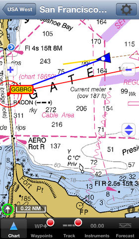
There are a variety of apps and charts available to boaters wanting to use mobile devices for navigating. One of these, iNavX, gives users the option of downloading a variety of electronic charts, serving as a kind of portal for marine navigation’s always-changing electronic chart inventory.
“iNavx makes your iPhone or iPad into a color marine chartplotter,” Rich Ray, owner ofGPSNavX, which markets iNavX, told TechNewsWorld. “You can upload all sorts of marine charts, and it shows your position on a chart and gives you directions. It will give you the distance, time, and bearings to take to get where you’re going.”
The app, which comes with free NOAA charts, also gives users the opportunity to purchase a variety of others. Once these charts are downloaded, they live on the mobile device and don’t require an internet connection to be accessed and used.
“It gives people another source of charting,” said Ray. “A lot of folks have built-in charters, but this is just a way to have it on your iPad or iPhone. If you sail on many different boats, you can take your iPhone or iPad with you. You don’t have to rely on the one that’s built into the boat. You can plan your route at home and take it on the boat, as opposed to waiting until you get on the boat.”
These mobile electronic charts and apps free boaters from having to be on the boat to chart their course, make plans, and review past trips. This freedom is particularly useful for people who don’t have their own boats and want to make plans for a trip from home.
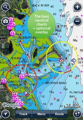
“It’s meant to be an all-around app for the marine community,” Don Black, global VP of sales and marketing with leading electronic chart provider Navionics said of the company’s marine and lake app, which is available both for iOS and Android. “It allows you to extend the enjoyment you get on your boat beyond your boat. You can plan and dream at home. The value of our app is to enlarge that overall experience.”
Not Always Seaworthy
They’re convenient and easy-to-use, but mobile devices like tablets and smartphones probably won’t entirely replace onboard navigation systems any time soon. For one thing, they can be easily broken or lost — making them better, some argue, as back-up devices than as primary navigation tools. Waterproof cases can help, but even those aren’t foolproof protection for devices that aren’t, after all, designed for use at sea.
“I wouldn’t suggest that people remove the [system] that’s on the boat,” Black told TechNewsWorld. “For one thing, mobile devices aren’t waterproof, and though there are dozens of waterproof cases, they’re not intended as marine electronic devices.”
Some of the problems facing mobile navigation tools are ones that face any onboard electronic navigation system — particularly the loss of power. In those cases, it might be best to resort to that most old-fashioned navigation tool: paper charts.
“Any electronic navigation aid has the ability to fail or lose power, often at inconvenient times,” said Collins. “It’s best to know alternate methods of navigating, and always carry physical paper copies of the general area in which you plan to sail. I tend to keep at least a wide-area chart and a few select harbor or coastal charts on hand in paper form every time I go out.”


Excellent article on how consmer mobile devices are making their way into navigator’s essential toolkits. Modern phones and tablets have become so powerful and reliable now that ENC charts are even available on web browsers. I remember a time when we used to pay a lot of $$$ for PCs and hardware for marine navigation.