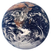
Time, Inc., together with Google, the U.S. Geological Survey, and Carnegie Mellon University's Create Lab, have set up a website featuring timelapse animations depicting changes in Earth's surface from 1984 to 2012.
The animations are based on images collected as part of the Landsat program, conducted jointly by the USGS and the U.S. National Aeronautics and Space Administationsince 1972, in which satellites take images of the Earth's surface.
The Timelapse project's website houses 25 planetary images, one for each year.
Landsat images "contain many layers of data collected at different points along the visible and invisible light spectra," USGS spokesperson Jon Campbell told TechNewsWorld. "Consequently, [they] can show where vegetation is thriving and where it is stressed, where droughts are occurring, where wildland fire is a danger, and where erosion has altered coastlines or river courses."
"We think it's important for people to have free access to this type of information that gives all of us a truly clear picture of how the Earth has changed as a result of human impact," Google spokesperson Nathan Tyler told TechNewsWorld.
Details of the Timelapse Project
Google, which has been digitizing Landsat images and putting them online jointly with the USGS since 2009, sifted through almost 2.1 million images -- more than 900 terabytes of data. The project found the highest-quality pixels for every year since 1984 for every spot on Earth, using Google Earth Engine technology.
It then compiled these images into annualized planetary images. Each image of the planet for one year is 1.8 terapixels in size.
Carnegie Mellon University's Create Lab then worked with Google to convert these annual images into a seamless, browsable HTML5 animation.
The lab did not respond to our request to comment for this story.
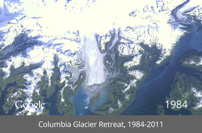
Views on the timelapse website include the deforestation of the Amazon rainforest in Brazil, the retreat of the Columbia Glacier in Alaska and the drying of the Aral Sea.
"Landsat satellites give us a view as broad as 12,000 square miles per scene while describing land cover in units the size of a baseball diamond," USGS's Campbell said. "From a distance of more than 400 miles above the Earth surface, a single Landsat scene can record the condition of hundreds of thousands of acres of grassland, agricultural crops, or forests."
All Landsat data is freely available to anyone, NASA spokesperson Stephen Cole told TechNewsWorld. USGS manages the Landsat data archive and its distribution. The data can be obtained here.
Time, Inc. did not respond to our request for further details.
What Landsat Offers
Landsat images "reveal subtle, gradual changes, such as Wyoming rangelands greening up after a drought, as well as massive landscape changes that occur in rapidly growing urban areas," Campbell said. "Landsat can also provide broad assessments of sudden natural or human-induced disasters, such as the number of acres charred by a forest fire or the extent of tsunami inundation."
Uses for Landsat data include monitoring of water quality, the recession of glaciers, the movement of sea ice, deforestation rates, and population growth.
In February, NASA launched the eighth satellite in the Landsat program, making up a gap in the program's ability to monitor the planet. Landsat 5 had been decommissioned earlier in the year, and Landsat 7 suffered a severe mechanical failure on a subsystem in 2003, rendering about two-thirds of each image unusable.
Landsat 8 had technical advancements in its sensors which project scientist Jim Irons told TechNewsWorld at the time would result "in the best data yet from our sensors."
The release of the timelapse data animations on Google's Earth Engine helps share this data with the public in an engaging new way, NASA said on Thursday.