Google Earth turned its gaze upward Wednesday with the debut of a new feature that allows users to view the best images of the sky captured by astronomers around the globe.
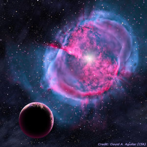
Called "Sky," the new feature lets Google Earth users view and navigate through 200 million galaxies. The images presented are a combination of those from numerous scientific third parties -- including the Space Telescope Science Institute, the Sloan Digital Sky Survey, the Digital Sky Survey Consortium, CalTech's Palomar Observatory, the United Kingdom Astronomy Technology Center and the Anglo-Australian Observatory -- stitched together by Google's engineers.
"We're excited to provide users with rich astronomical imagery and enhanced content that enables them to both learn about what they're seeing above and tell their own stories," said Lior Ron, a product manager with Google. "By working with some of the industry's leading experts, we've been able to transform Google Earth into a virtual telescope."
Informational Layers
In addition to the raw images, Sky also includes seven informational layers focusing on particular celestial bodies and events. The Constellations layer, for example, connects the points of constellations through space, labeling each and providing information about the stars that are part of them.
The Backyard Astronomy layer, meanwhile, is designed to help amateur astronomers learn more about particular fragments of the night sky by allowing them to click through information on stars, galaxies and nebulae that are visible to the eye or via binoculars and small telescopes.
Sky's other informational layers focus on Hubble Space Telescope Imagery, a guide to the galaxies, the moon, planets and the life of a star.
Questions About the Sky
To access Sky, users select Switch to Sky from the "view" drop-down menu in Google Earth, or click the Sky button on the Google Earth toolbar. The interface and navigation are similar to that of the rest of Google Earth, including dragging, zooming, search, My Places and a layer selection.
"Sky is a very cool new feature for anyone who has ever looked up at the sky and wanted to know more," said Sally Ride, former astronaut and CEO of Sally Ride Science. "I think this is a great tool for satisfying that curiosity."
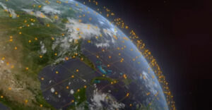
Last month a NASA layer group was added to Google Earth showcasing NASA's exploration. The group has three main components, including Astronaut Photography of Earth, Satellite Imagery and Earth City Lights.
Fostering Understanding
"Never before has a road map of the entire sky been made so readily available," said Carol Christian of the Space Telescope Science Institute, who co-led the organization's Sky team with Alberto Conti.
"Anyone interested in exploring the wonders of our universe can quickly see where the stunning objects photographed by Hubble actually dwell in the heavens," Christian added. "Sky in Google Earth will foster and initiate new understanding of the universe by bringing it to everyone's home computer."
Indeed, the ability to focus on particular portions of the sky is a particularly useful addition for amateur viewers, Mario Livio, senior astrophysicist with the Space Telescope Science Institute, told TechNewsWorld.
Adding Context for Amateurs
"We think this is great because it clearly provides anyone with a computer not only immediate access to our discoveries, but also immediate access in the context of the current position of the sky," Livio explained.
"You could get information about Hubble discoveries from our Web site before this, but now you can tour the sky you see from your backyard and see what interesting objects Hubble has looked at in that portion of the sky," he added.
Sky is also notable for the way it amasses and makes accessible in one place data that various government organizations have had in bits and pieces for years, Paul Czysz, professor emeritus of aerospace engineering at St. Louis University, told TechNewsWorld.
The Corporate Contribution
"It's fascinating," he said. "This shows what happens when a commercial firm that's really an information firm gets the data and puts it out there."
In that way, the innovation is similar to the opening up of the Dead Sea Scrolls after they had been protected from the public view for years, Czysz added.
"Finally somebody did something about it," he said. "I thought Google Earth was doing well when I could see my house."