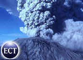
Due to its proximity to urban areas and its volatile activity in recent decades, Mount St. Helens may be the most closely monitored volcano in history.
Digital telemetry — systems that automatically record and transmit data from remote sources — circles the crater like a bracelet. Sensors monitor conditions ranging from lake levels to earthquakes, and share their findings over a worldwide network. Technology used to monitor the site now include heat visualizers on drone aircraft — a far cry from the wooden yardsticks that used to be nailed to stumps to measure the tilting of a lakebed.
Sensors keep watch at places with names that reflect the folkloric quality of volcanoes — especially this one in Bigfoot country — such as Spirit Lake, Ape Cave and Sasquatch Gulch. And they precisely report real-life conditions on top of a bubble of molten rock.
Data Shared Worldwide
No single network links the entire array of instruments. Most connections are by VHF or UHF radio, linked to scientists at the Vancouver headquarters of the Cascades Volcano Observatory, where staff treats the volcano like a laboratory. A battery of PCs running custom and off-the-shelf software directs the instruments. “Some of the programs we’ve written, and others are canned,” said U.S. Geological Survey geophysicist Ed Brown. Even cell phones are linked to the data reports, and the rare visual observation is entered by keyboard.
For a starting point, seismographs show underground fracturing, marking earthquakes as frequent as one a minute apart. These data are shared over the Pacific Northwest Seismograph Network operated by the University of Washington to monitor volcano seismicity from Northern California’s Mount Shasta to Washington’s Mount Rainier. According to Brown, the data is accessible to vulcanologists worldwide.
Gaseous emissions and temperatures are sampled for changes in fumarole gas, possibly related to the magma supply rate, changes of magma type, or changes in escape routes from magma movement.
Predicting Eruptions
Geodetic networks measure changes on the volcano surface from the pressure of underground magma movements. A laser light source measures surface tilt, and by leveling surveys detect elevation changes. Deformation increases as magma rises and can help predict an eruption. Ground displacement on steep volcanoes may indicate slope instability.
Mount St. Helens is a steep stratovolcano, formed over centuries by a long series of eruptions including lava flows that bind earlier ash deposits under a conical cap.
Soon after its 1980 eruption, three networks were set up to monitor outer deformation. These include a “far-out net,” “outernet” and another for internal dimensions. They contain Global Positioning System equipment with accuracy within centimeters.
Ground Water Gages
Ground water is suspected of playing a role in eruptions, so streamflow and sediment content of rivers and lakes, and snow and ice accumulations are recorded. These may indicate the role of ground water in predicting eruptions, and the hazard of mixing hot volcanic products with snow, ice and surface streams. It also relates to the long-term flood hazards from infilled river channels. Gaging stations measure flow and and sediment discharge for use in flood predictions and sediment control. River-channel cross-sections are measured at moe than 150 sites.
Lakes raised by debris dams are monitored as well. Fear that debris-dam failures could produce catastrophic mudflows prompted the U.S. Army Corps of Engineers to stabilize water levels and monitor lake gages on three lakes. These gages comprise an emergency warning system. Each has at least two recorders to transmit lake elevations hourly by satellite to a ground station in Tacoma. If a lake level drops fast, alerts are sent out every five minutes.
Precursor monitoring is conducted by the observatory, which has a call-down system to related agencies and to the media. Mount St. Helens is also watched by the Federal Aviation Administration, which has access to eyeball reports from pilots of aircraft from nearby Portland International Airport.